NASA launched their Global Precipitation Measurement Mission or GPM core satellite to monitor weather and render their pattern in 3D. On April 24, 2017, at 2100 UTC (5 p.m. EDT) it has detected a newly formed Tropical Depression 03W in the middle of Pacific ocean. The formation took place about 201 nautical miles north-northwest of Yap and the west of Guam.
NASA reported on their official web page that on April 14, 2017, at 1901 UTC (3:01 p.m. EDT) while GPM satellite was gliding over Pacific ocean had an excellent view of Tropical Depression 03W or TD03W. The 3D rendered animation of tropical depression indicate the presence of some very powerful convective storms.
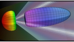
GPM was engineered by the joint collaboration with NASA and Japan Aerospace Exploration Agency (JAXA). Dual-Frequency Precipitation Radar (DPR) and GPM's Microwave Imager (GMI) instruments captured dropping rains at 215 mm (8.5 inches) per hour speed in the convective storm towers on the eastern side of this cluster. Later, scientists from NASA's Goddard Space Flight Center in Greenbelt, Maryland constructed a 3D rainfall structure from the radar data.
NASA Goddard scientist and the Creator of GPM’s imagery and an animation Hal Pierce said,“Intense downpours in some of these storms were returning radar reflectivity values exceeding 59.7 dBZ to the satellite”. dBZ stands for “decibel relative to Z”,which is a logarithmic dimensionless technical unit, mostly used in weather radar to compare the equivalent reflectivity factor (Z) of a radar signal reflected off a remote object (in mm^6 per m^3) to the return of a droplet of rain with a diameter of 1 mm (1 mm^6 per m^3).
According to EurekAlert, the left sided cluster of the convective storm has reached about 11.0 miles(17.8 km) of altitude. On April 25, 2017, at 1500 UTC (11 a.m. EDT), GPM recorded the winds of Tropical Depression 03W has blown over 30 knots of speed while centering to 13.1 degrees north latitude and 135.5 degrees east longitude.
Now TD03W is shifting towards the northwest coast at about four knots of speed. However, the Joint Typhoon Warning Center (JTWC) has predicted that the Tropical Depression 03W will become more powerful and cause a tropical storm in the northeast at ~45 Knots of speed.


![Sat-Nav in Space: Best Route Between Two Worlds Calculated Using 'Knot Theory' [Study]](https://1721181113.rsc.cdn77.org/data/thumbs/full/53194/258/146/50/40/sat-nav-in-space-best-route-between-two-worlds-calculated-using-knot-theory-study.png)