Some hurricanes form an eye, while others do not. The science underlying it will be clarified in this post as the equipment that sends data to the weather station.
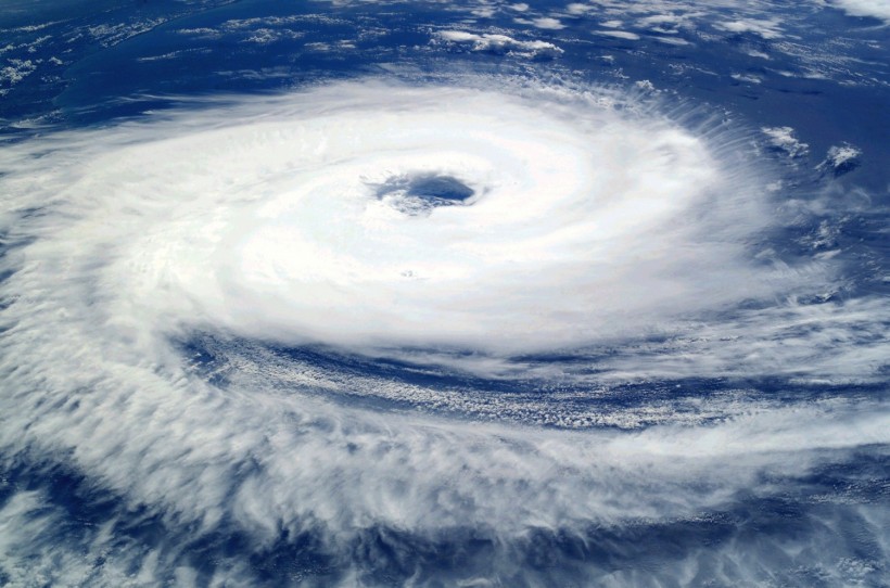
Hurricane Eye
How Are Hurricanes Formed?
According to Forbes, storms frequently develop from a cloud mass or tropical disturbance. A system can transform into a tropical depression, a rotating system of thunderstorms, if favorable conditions are present. The favorable conditions include ocean water temperatures of at least 79 degrees Fahrenheit over a depth of at least 50 meters, enough moist air, and little change in wind speed or direction within the atmosphere. Depending on sustained wind speeds, a storm may be classified as a tropical storm (39 mph) or a hurricane (74 mph).
Why Do Some Hurricanes Have Eyes?
The eye of the storm typically consists of a clear zone of sinking air and mild winds, which are often no faster than 15 mph (24 km/h) and measure 20 to 40 miles (32 to 64 km) wide. An eye typically forms when the maximum sustained wind speeds exceed 74 mph (119 km/h). The eye is the calmest part of the storm.
For a quick illustration, consider this from seeing figure skaters spin. They spin more quickly the closer they keep their hands to their bodies. In contrast, the hands rotate more slowly the further away from the body they are. In a storm, it means that as the air flows into its core, the speed increases.
However, the conservation of angular momentum is undoubtedly under consideration. According to the Jet Stream website, the centrifugal force is stronger when the curvature is sharper and/or faster than the rotation around the hurricane.
There are still numerous unanswered questions regarding eye formation from a scientific standpoint, according to a 2017 study published in the Journal of Fluid Mechanics. On the other hand, according to Rafi Letzter's article in Live Science, a cyclone's eye develops internal friction, speed, and the force of the Earth's rotation acting on the storm, striking a delicate balance.
ALSO READ: First Ever Space Hurricane With 621-Mile Mass of Swirling Plasma Confirmed
Specialized Aircraft
NOAA has a variety of instruments for hurricane forecasting. The ability to predict hurricanes using radar, satellites and computer models are useful, but each has its limitations. NOAA uses two Lockheed WP-3D Orion aircraft to undertake low-altitude data collection to get around these restrictions and fill in the data gaps not covered by ground-based radar or satellite imaging.
For observations of the atmosphere, the earth, and its environment, NOAA's WP-3D Orions are outfitted with a distinctive array of scientific equipment, radars, and recording systems. These sturdy and well-maintained aircraft were purchased as brand-new models off the Lockheed assembly line in the middle of the 1970s, and they have guided NOAA's ongoing efforts to track and study hurricanes and other severe storms. The level of data collected by these aircraft has been excellent.
The "Kermit" (N42RF) and "Miss Piggy" (N43RF), the aircraft's nicknames, have assisted in hurricane and tropical storm research in the Atlantic, Caribbean, Gulf of Mexico, and Eastern Pacific.
Additionally, the WP-3D Orions have equipment for the tail Doppler radar (TDR) and lower fuselage (LF). The TDR scans vertically while the LF radar monitors the storm horizontally to the aircraft's belly. Together, these tools give scientists and weather forecasters an inside-the-storm view of the storm, similar to an MRI, enabling them to see all the different layers and interior structures.
RELATED ARTICLE: Eye of Hurricane Dorian Spotted From The International Space Station
Check out more news and information on Environment in Science Times.


