Astronauts on the International Space Station (ISS) routinely take pictures of unique views of Earth hundreds of miles above the surface. They showcase both beauty and destruction on Earth, like the erosion of the Sahara Desert.
A recently shared photo from NASA's Earth Observatory shows dark, flat-topped mesas that stand out amid the surrounding lighter-toned landscaped in the northwestern part of Sudan.

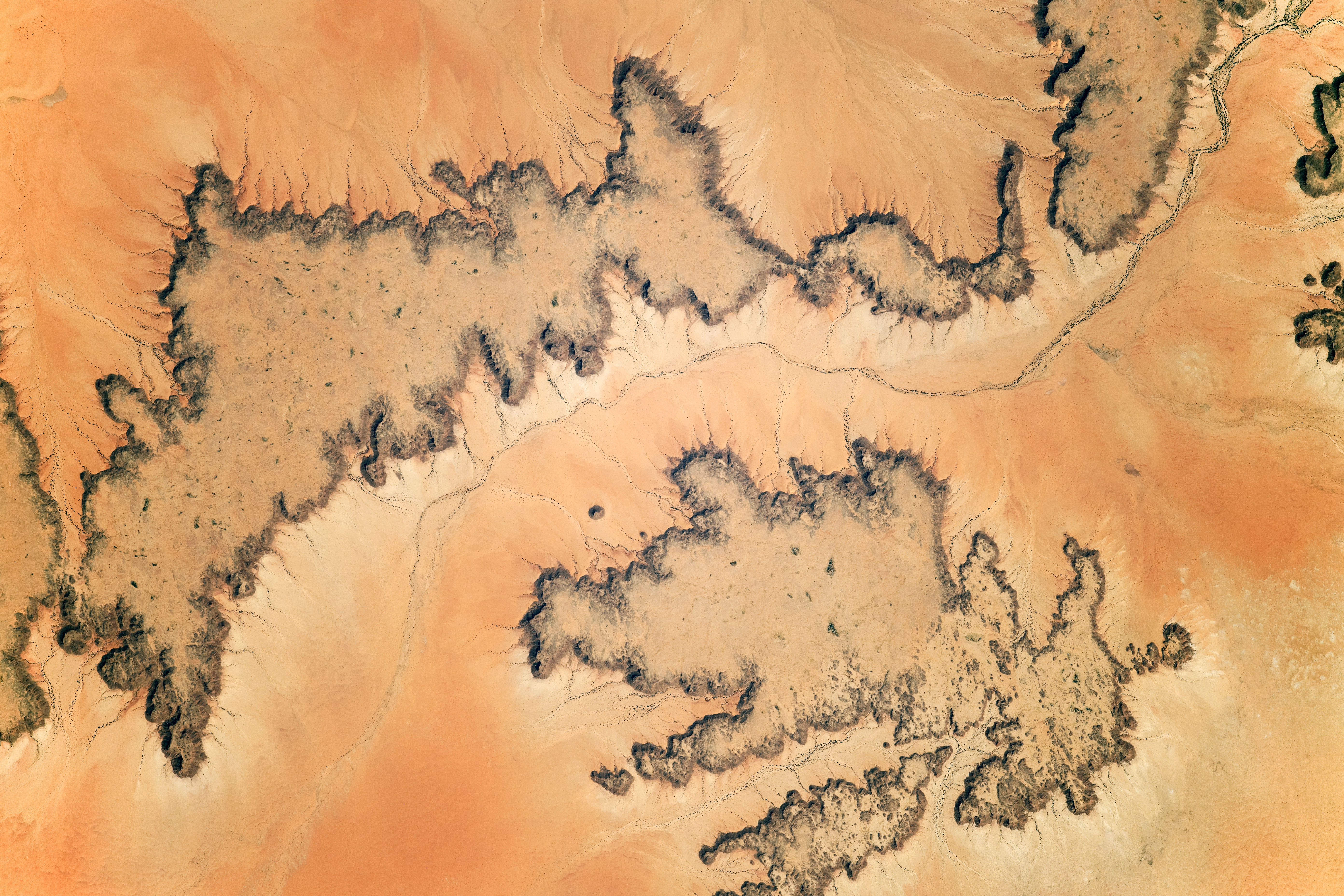
Mesas in the Sahara Desert As Seen From Space
The Sahara Desert is the largest desert in the world that fills nearly all of northern Africa with an approximate total area of some 3,320,000 square miles (8,600,000 square km), per Britannica.
Its principal topographical features include shallow, seasonally inundated basins, large oasis depressions, extensive gravel-covered plains, rock-strewn plateaus, mountains, sand sheets, duns, and sand seas.
The detailed photo taken by astronauts shows dark surfaces in the hyper-arid eastern Sahara Desert in Sudan. According to NASA, these land formations are dark, flat-topped mesas that rise 230-460 feet (70-140 meters) above light-toned surrounding landscapes. The mesas are defined by vertical cliffs cut into by numerous small gullies that produce an indented pattern.
A dotted pattern of trees and clumps of bushes are also visible in the photo in which they follow the line of the riverbed, suggesting that their roots are reaching the subsurface water.
The photograph was taken on December 25, 2019, by a member of the Expedition 61 crew. The ISS Crew Earth Observations Facility and the Earth Science and Remote Sensing Unit, Johnson Space Center provided the image that has been cropped and enhanced to improve contrast and remove lens artifacts.
The ISS Program supports the laboratory as part of ISS National Lab's aim to help astronauts take photos of Earth that will give the greatest value to scientists and the public, making them freely available on the world wide web.
Erosion in the Desert
Weathering in desert climates takes place by means of higher temperatures, and water as the main agent. Chemical weathering takes more slowly in deserts than in humid climates because of the lack of water. On the other hand, mechanical weathering is slowed due to a lack of runoff and moisture to perform ice wedging.
Geologists interpret the evolution of the area in northwestern Sudan by analyzing the height of the mesas and the rock units exposed in the cliff. They conclude that the rock layer forming the two mesas was more extensive before and now it has been stripped away by river and wind erosion that produced the younger, lighter-toned surface.
Chemical weathering processes are usually the reason for the eroded desert landscapes with contrasting darker and lighter-toned surfaces, like those found in the Sahara Desert. Geologic maps of the area suggest that it is a single rock type called Nubian Sandstone, one of the biggest fossil water aquifers in the world.
RELATED ARTICLE : Red Himalayan Glacial Lake Discovered Using Satellite Images Taken Over the Past 20 Years
Check out more news and information on Environment and Climate in Science Times.
© 2026 ScienceTimes.com All rights reserved. Do not reproduce without permission. The window to the world of Science Times.


