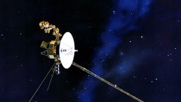
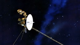
In March and April, NASA detected early indications of El Niño using satellite data from the Sentinel-6 Michael Freilich. The satellite is primarily designed to track sea levels and captured the movement of warm water in the Pacific Ocean as it traveled eastward towards the western coast of South America.
According to Live Science, these observations included the presence of Kelvin waves, which are large ocean waves spanning hundreds of miles in width but only measuring 2 to 4 inches (5 to 10 centimeters) in height. Kelvin waves typically form near the equator and play a role in redistributing warm surface water to the western Pacific, serving as a precursor to El Niño.

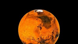
This satellite image taken 10 November and released by the Jet Propulsion Laboratory and NASA 18 November shows the El Nino weather phenomena, represented by the the white area at the equator.
NASA Continues To Monitor Kelvin Waves If It Develops Into El Niño
NASA's Sentinel-6 Michael Freilich satellite has detected early signs of a potential El Niño event, prompting scientists to closely monitor its development. Josh Willis, a project scientist at NASA's Jet Propulsion Laboratory, emphasized in a news release from NASA's Jet Propulsion Laboratory (JPL) the significance of a strong El Niño, stating that it could lead to record global warming.
The National Atmospheric and Oceanic Administration (NOAA) has indicated a 90% probability of El Niño occurring this year, persisting into the winter of the Northern Hemisphere.
NOAA predicts an 80% chance of at least a moderate El Niño, characterized by a 1.8 degrees Fahrenheit (1 degree Celsius) increase in ocean surface temperatures. Furthermore, there is a 55% chance of a strong El Niño, resulting in a rise of 2.7 degrees Fahrenheit (1.5 degrees Celsius) in temperatures.
Data from the Sentinel-6 satellite, captured between March and April, revealed the movement of Kelvin waves, transporting warm water eastward and accumulating off the coasts of Colombia, Ecuador, and Peru. As Live Science reported, these images illustrate regions of warmer water and higher sea levels, highlighting the impact of ocean waves in distributing heat and moisture along coastlines.
NOAA and NASA will continue monitoring conditions in the Pacific in the coming months to assess the likelihood and intensity of El Niño. Josh Willis anticipates the potential for another wet winter in the Southwest U.S., building upon the previous year's precipitation. Additionally, with the conclusion of the last La Niña event, coupled with supercharged ocean temperatures, Willis anticipates the possibility of a series of record-high temperatures in the next 12 months.
The combined effects of El Niño and intensified ocean temperatures paint a picture of potential climate extremes, underscoring the need for ongoing research and monitoring to better understand and prepare for the implications of these phenomena.
READ ALSO: Global Warming Is Escalating The El Niño Weather
More About El Niño
As per NOAA, El Niño is a climatic phenomenon characterized by warmer-than-average surface water in the equatorial Pacific and weaker-than-normal east winds. These events typically occur every 3 to 5 years.
The term "El Niño" originated in the 1800s when Pacific coast fishermen noticed the recurring appearance of a warm ocean current. This warm water, arriving around Christmas, led to significant drops in fish catches, negatively impacting the food supply and livelihoods of coastal communities in Peru.
In reference to the birth of Christ, they named the warm ocean waters "El Niño," meaning "the boy" in Spanish. In contrast, fishing in the region is most productive during La Niña years, when cold upwelling ocean water from the deep ocean brings nutrient-rich waters, resulting in increased fish populations.
El Niño is associated with weakened trade winds, which push the warm water eastward. This has a notable influence on global weather patterns. In the United States, it leads to wetter conditions in southern regions and hotter weather in the northwestern areas.
RELATED ARTICLE: Can Artificial Intelligence Predict the Occurrence of El Niño?
Check out more news and information on El Niño in Science Times.


![Humans Will Go Extinct on Earth in 250 Million Years; Mass Extinction Will Occur Sooner if Burning Fossil Fuels Continues [Study]](https://1721181113.rsc.cdn77.org/data/thumbs/full/53373/89/56/50/40/humans-will-go-extinct-on-earth-in-250-million-years-mass-extinction-will-occur-sooner-if-burning-fossil-fuels-continues-study.jpeg)