Satellite photos captured during Russia's Klyuchevskoy volcano eruption showed a huge plume of smoke and ash. The violent eruption of the tallest volcano in Europe and Asia happened earlier this month.
Satellite Photos of Klyuchevskoy Sopka's Eruption
On Nov. 1, Klyuchevskoy Sopka's erupted, throwing a 1,000-mile-long (1,600 kilometers) cloud of dust and ash into the air. The active volcano has been erupting since mid-June, but the incident earlier this month was a massive explosion with the torrent of smoke and ash reaching a maximum height of 7.5 miles (12 km) above Earth's surface, per NASA's Earth Observatory.
Klyuchevskoy, also known as Klyuchevskaya Sopka, is an active stratovolcano on the Kamchatka Peninsula in Russia. The peninsula is also home to over 300 other volcanoes. According to the Kamchatka Volcanic Eruption Response Team (KVERT), Klyuchevskoy is the tallest volcano in Asia and Europe, with a peak elevation of 15,584 feet (4,750 meters) above sea level.
Planes in the vicinity were grounded when KVERT momentarily raised the aviation alert level to red, the highest level, due to the smoke and ash plume. The rise in air pollution also resulted in the evacuation of some schools.
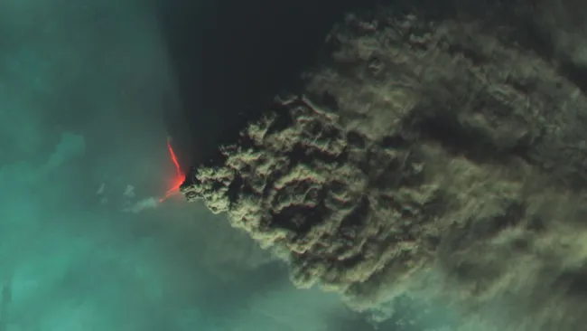
NASA and the United States jointly operate the Landsat 8 satellite. The Geological Survey photographed the eruption plume in a dramatic false-color image shown here. The image contrasts the red lava plume and grey smoke with the blue clouds.
NASA's Aqua satellite also took a broader true-color image of the plume, seen below. The picture indicates that the river of smoke was approximately 1,000 miles long at the time. However, the plume might have eventually reached a length of 1,400 miles (2,255 km), as per the Smithsonian Institution's Global Volcanism Program.
The eruption lasted only a few days, and Klyuchevskoy may have stopped erupting.
The Kamchatka Peninsula is a portion of the Pacific Ring of Fire. This tectonic belt encircles the Pacific Ocean and spans 25,000 miles (40,200 km), home to about 75% of the world's active volcanoes.
Nearly 50 Active Volcanoes Erupting At The Same Time
Based on the weekly report from the Global Volcanism Program of the Smithsonian Institution last week, 46 volcanoes were erupting simultaneously. The information did not include the dozens of volcanoes showing eruptive activities for decades or more.
The three volcanoes added last week included Iwo Jima, Japan; Grindavík, Iceland; and Kamchatka, Russia. The Icelandic volcano has shown many indicators of instability, including thousands of earthquakes and the sinking of a significant amount of land in Grinadvík, which indicates that magma is reaching the volcano ahead of an eruption. It was included in the list due to the change in activity.
Despite the number of volcanoes in eruptive states, Global Volcanism Program Director Ben Andrews said there was nothing to worry about because the rate is average. According to him, 40-50 eruptions are generally happening at any given time.
Check out more news and information on Volcanic Eruptions in Science Times.
© 2025 ScienceTimes.com All rights reserved. Do not reproduce without permission. The window to the world of Science Times.


