New South Wales and Canberra is set to experience the effects of this weekend's chilling temperatures brought by a freak polar blast that only happens once every 15 years. Icy winds, heavy rain, and snow are expected to cover the east coast of Australia this weekend.
The maximum temperature of Sydney would reach only 60.8 degrees Fahrenheit (16 degrees Celsius) and a minimum temperature of 46.4 degrees Fahrenheit (8 degrees Celsius). Plus, snow will fall in areas 500 meters above sea level, and to the outskirts of Melbourne and Sydney.
Dean Narramore of the Bureau of Meteorology said that the strong cold front would drag air all the way from Antarctica with rain showers, hail, thunder and snow across south-eastern Australia.
Spectacular satellite imagery showing the deep Antarctic air mass approaching south east Australia. pic.twitter.com/V2PNsKkzrD — Andrew Miskelly (@andrewmiskelly) August 20, 2020
Freak Polar Blast Set to Cover East NSW
Wild weather composed of a widespread rain shower, hail, thunder, and strong winds will sweep across Victoria and New South Wales late Friday and early Saturday, Narramore said.
He explained that the snow would fall to at least 600 meters in Victoria and across New South Wales Central and Southern Tablelands.
Furthermore, outer parts of Melbourne will also experience snow, including Mount Dandenong, Mount Macedon, as well as some parts of the central and eastern ranges. The heavy rainfall combined with strong winds will lead to blizzard-like weather at times for mountainous areas on Friday and Saturday, Narramore said.
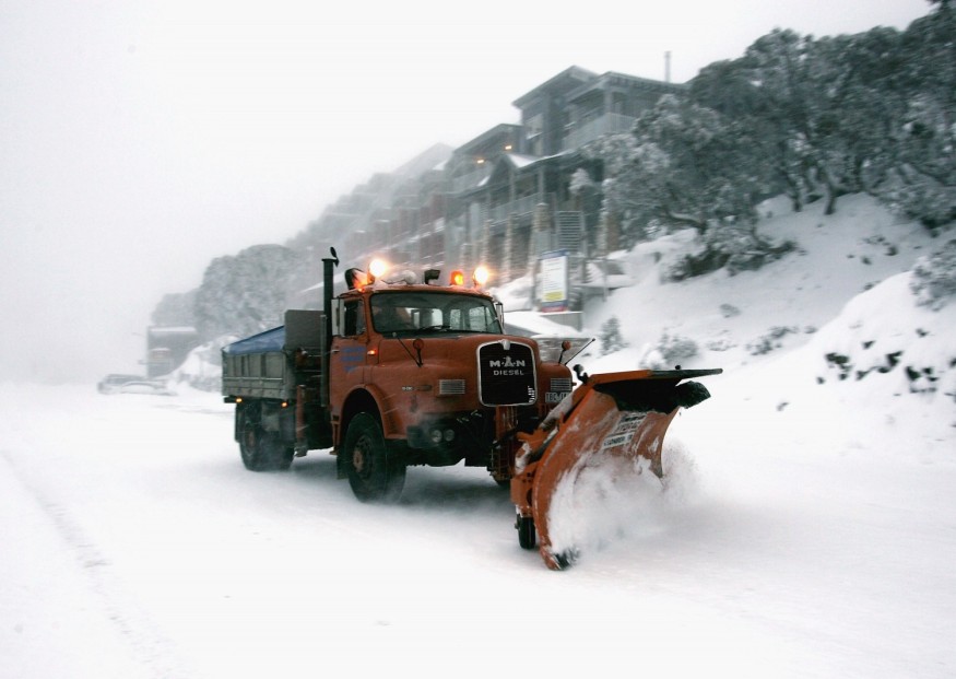
He further warns that the snow can reach 100 centimeters, leading to many road closures and would make driving conditions dangerous and hazardous.
Due to the wild winds and cold temperatures that are likely to continue until Monday, August 24, many parts of Australia will also experience the coldest day this year.
READ: Cold Snap Strikes Australia Sends Temperature Plummeting Below Freezing Point and Hail Storm
Temperatures Plummeting
Bureau of Meteorology's Jane Golding said the freak polar blast would make temperatures to plummet for as low as 50 degrees Fahrenheit (10 degrees Celsius) below the average on Saturday. Over the weekend, high winds and cold temperatures are expected as well as some snow to sweep across the New South Wales that are generally not seen.
The polar blast is slowly starting as gusty winds developed over a lot of areas in NSW, and those winds have blown some dust over its western side.
Temperatures are expected to plummet to 41 degrees Fahrenheit (5 degrees Celsius) in Orange, Canberra, Katoomba, and Goulburn. But due to the strong winds, it would feel more like 26.6 to 23 degrees Fahrenheit (-3 to -5 degrees Celsius), Golding said.
On Saturday, the maximum temperature in Sydney will be 60.8 degrees Fahrenheit (16 degrees Celsius) and a minimum temperature of 46.4 degrees Fahrenheit (8 degrees Celsius).
It will snow for at least 36 hours in Lithgow, Cooma, Batemans Bay, and Orange this weekend.
At the same time, Melbourne's temperature is expected to be at 53.6 degrees Fahrenheit (12 degrees Celsius) on Friday and over the weekend. Brisbane is expected to have a temperature of 73.4 degrees Fahrenheit (23 degrees Celsius) with winds of up to 45kph.
It will be raining in Adelaide with a maximum temperature of 42.8 degrees Fahrenheit (6 degrees Celsius) this weekend.
Fortunately for Perth residents, they will enjoy a mostly sunny day on Friday before experiencing the cold weekend.
READ MORE: Google's Open Letter to Australia Warns Government to Ban Free Search Services in the Country
Check out more news and information on Environment & Climate on Science Times.
© 2026 ScienceTimes.com All rights reserved. Do not reproduce without permission. The window to the world of Science Times.


