Scientists are even seeking evidence of the eruption of the Tonga Volcano in space. The eruption column reached the stratosphere, the next layer of the atmosphere above the ground, after reaching the stratosphere.
According to Science Alert, the roar of the explosion was heard hundreds of kilometers distant in Canada's Yukon Territory. The sound waves were even recorded by barometers in the UK, although being below the limit for human hearing.
The eruption also seems to have created a series of "atmospheric gravity waves," which were spotted by a NASA satellite and radiate outwards in concentric rings from the volcano.
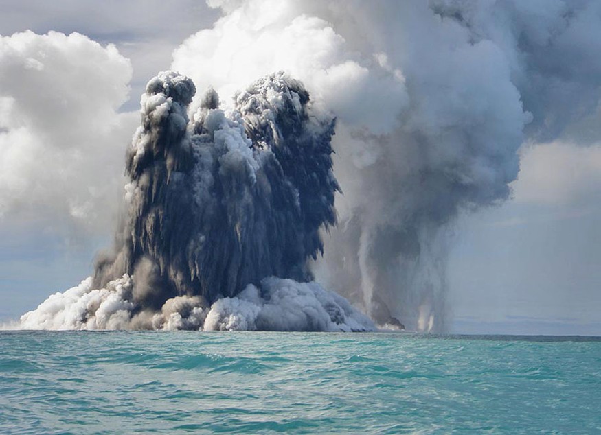
NUKU'ALOFA, TONGA - MARCH 18: An undersea volcano is seen erupting off the coast of Tonga, sending plumes of steam, ash, and smoke up to 100 meters into the air, on March 18, 2009, off the coast of Nuku'Alofa, Tonga. The volcano, which is situated approximately 6 miles off of the main Tongan island of Tongatapu, is one of around 36 undersea volcanos clustered in the area. There is currently no danger to residents of the island as the gases are blown offshore, and residents noted the eruptions began on Monday after a series of sharp earthquakes were felt in the capital.
Astronaut Onboard ISS See Ash Clouds From Tonga Volcano Eruption
The aftermath of a major volcanic explosion that ripped away a tiny island in the Pacific Ocean and threw tons of ash into the atmosphere on Jan. 15 was caught by astronauts on the International Space Station (ISS).
Several meteorological satellites filmed the eruption live, capturing the vast cloud that covered the whole Polynesian Kingdom of Tonga shortly after the detonation, like a nuclear explosion.
Space.com said the volcanic ash generated by the explosion was subsequently detected at heights of up to 39 kilometers (24 miles), giving astronauts aboard the orbiting outpost a terrifying sight.
On Jan. 16, NASA astronaut Kayla Barron took four photographs of the ash plumes as the station sailed over New Zealand, some 1,200 miles (2,000 kilometers) south of the volcano. Darkened skies above Earth are shrouded by heavy ash clouds in the photographs.
@twitter|https://twitter.com/NASA_Astronauts/status/1483889557301047300@
The damage inflicted by the tsunamis and ashfall after the eruption on the surrounding islands, including the Kingdom of Tonga's principal island Tongatapu, was photographed by satellites operated by Maxar Technologies. Because the tsunami crippled communication networks in the region, disaster response experts are still analyzing the damage.
The tsunami that the eruption caused spread far beyond Polynesia. Parts of the Pacific coasts of both the Americas and New Zealand and Japan were all under warning. While the alerts have since been rescinded, local officials have warned that the volcano might erupt again, resulting in tsunamis.
Experts Now Investigate Tonga Eruption Ripples on Space
When atmospheric gravity waves from a volcanic eruption reach the ionosphere, The Conversation said "traveling ionospheric disturbances" might occur. These are compression waves that may dramatically boost plasma density variations in a short amount of time and travel thousands of kilometers worldwide. These impacts may wreak havoc on contemporary technology, causing satellite global positioning systems (GPS) to lose precision.
In the past, volcanic eruptions have been linked to detectable ionosphere changes recorded by GPS devices on the ground, like in 2013 and 2015.
Experts used data from a Low-Frequency Array facility (Lofar) to analyze these disruptions more than their effects on GPS. Lofar is one of the world's largest radio telescopes, consisting of hundreds of radio antennas dispersed across Europe and designed to monitor distant natural radio sources such as radio galaxies in the early cosmos.
Richard Fallows developed the video uploaded on YouTube (also embedded below), displaying some Lofar data from December 2013. Natural radio sources, such as distant galaxies, are the brilliant points of light. The sequence in the left panel depicts a peaceful night, whereas the ionosphere is disrupted in the right part. The sources appear to shift location and fade in and out quickly.
Experts will examine our Lofar data in the following weeks to see if any specific trends might be linked to the Tongan eruption. Finally, the discovery might aid our understanding of how Earth's volcanoes affect space and technology. Because the ionosphere is the atmospheric interface between Earth and space, it may reveal how much of the disruption is caused by terrestrial vs. space weather events.
RELATED ARTICLE : Kīlauea Caldera Survey Helps Check Possible Changes in Volcano's Gas Emissions After 2018 Eruption
Check out more news and information on Volcanoes and Space in Science Times.
© 2026 ScienceTimes.com All rights reserved. Do not reproduce without permission. The window to the world of Science Times.


