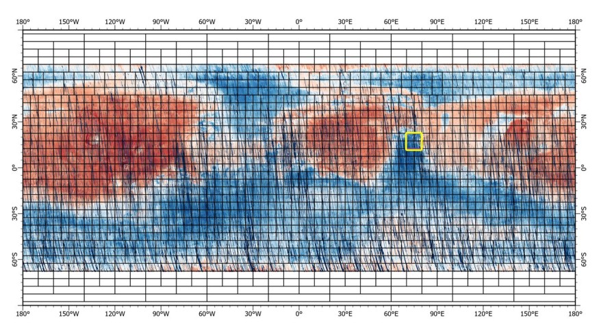
The photos with rainbow hues might be considered works of art. But don't fall for it. These images of Mars were captured by NASA's Mars Reconnaissance Orbiter's Compact Reconnaissance Imaging Spectrometer for Mars (CRISM).
The spacecraft has been orbiting Mars since 2006, using cameras like HiRISE to take images of the planet and spectrometers and radar to gather data. As a spectrometer, CRISM separates light into various wavelengths to ascertain the composition of an item. By utilizing different colors to represent different minerals on the planet's surface in the maps below, scientists may study the Martian geology from orbit.

NASA Mars Reconnaissance Orbiter Shares Clear 5.6 GP Map of Mars
According to SciTechDaily, the Mars Reconnaissance Orbiter (MRO) has provided a new map of Mars for everyone to see. Since it obtained a 5.6-gigapixel image of the Red Planet's map, the photo was divided into sections. The map depicts the whole planet in its present condition and includes the craters, rocks, and erosions that the on-ground rovers see.
A 5.6 gigapixel rainbow-colored map that spans 86 percent of the surface of the red planet was posted on NASA's official Twitter account on June 25, 2022. The space agency said that there are 51,000 images on this card.
The data is accessible through NASA's Planetary Data System, which also holds the initial portion of the map that the MRO shared with the globe. Since it is more than just a picture of the planet as seen from space, it gives the world a new appearance.
Similar to the early maps of the Earth, it shows the whole surface of Mars and includes the information that future researchers would need to effectively explore the Red Planet.
A map of any place or thing is essential because it provides directions and tells people where to search for whatever they are looking for. The same is true of Mars, a mysterious planet with a sizable region that will be investigated and studied by future astronauts as the next home for humankind.
ALSO READ : Mars Reconnaissance Orbiter Captures Clay-Bearing Sediments; Are Wee Seeing Signs of Martian Life?
About MRO's Camera
The MRO's cameras provide a more up-to-date image of the planet that would apply to both space and the Martain surface whenever explorers set down.
Scott Murchie, a planetary scientist at the Johns Hopkins Applied Physics Laboratory (APL) in Laurel, Maryland, and CRISM's principal investigator, said the map presented a "whole new data set" that will surely help the study of the Mar's surface composition.
He added that one of the goals of the next MRO extended mission is for the HiRISE camera to return and capture colored images of "new high-science priority spots," especially those places without high-resolution photos available to learn about their significance.
Another map of iron-bearing minerals will also be revealed later this year. These minerals are helpful in understanding the history of water on Earth and may even aid in the hunt for signs of prehistoric life.
RELATED ARTICLE : 5 Best Space Images Captured by NASA Telescopes Shows Mind-Blowing Occurrences Outside Earth
Check out more news and information on Space in Science Times.
© 2026 ScienceTimes.com All rights reserved. Do not reproduce without permission. The window to the world of Science Times.


