NOAA's National Weather Service reports that on February 17 and 18, 2022, a powerful winter storm delivered snow, sleet, and rain to the Great Lakes region of the United States and Canada. Then on February 20, 2022, an astronaut onboard the International Space Station (ISS) took a shot of the Great Lakes after the storm.
Despite the snowstorm, experts said that the Great Lakes entered winter with record-warm waters, as well as a strong "La Niña" pattern of colder Pacific surface waters that pushes northward the jet stream. Collectively, the weather phenomena are influencing the air currents in keeping the Great Lakes air-free.
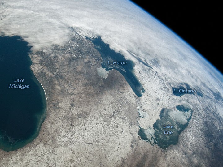
Snow, Ice Covered the Great Lakes in the US and Canada
According to NASA's Earth Observatory, the space station was directly above northern Iowa at the time, but the oblique angle of the view reveals places further east, including Michigan, Ontario, and the Great Lakes.
Parts of northern Michigan and Ontario were cloudy, although bright sky persisted further south. There is a snow belt separating Lake Huron and Lake Erie and in some areas, the storm dumped over 7 inches (18 cm) of snow.
The image also shows a lot of ice on Lake Huron, particularly in Saginaw Bay, and over most of Lake Erie. The Great Lakes ice cover as per NOAA-GLERL reached its maximum extent for the winter of 2021-2022 nearly a week later, measuring slightly over normal as per calculation since the start of record keeping in the early 1970s.
Individual lakes' ice may form earlier or later depending on daily circumstances. For example, the ice cover on Lake Erie reached 94% in late January 2022 then subsequently fell to 62% on February 3 before rising to 90% on February 5.
By the time the photograph was taken on February 20, coverage had reduced to 81%. Rapidly changing ice cover is frequently caused by rapid variations in the wind or air temperature.
Low Great Lakes Ice Cover
Ice development is influenced by elements such as the lake's latitude, size, and depth. Lake Michigan and Lake Ontario, which are substantially deeper than Lake Erie, are still largely unfrozen in the photograph.
The uncovered water of these lakes can produce moisture for lake-effect snow. The event led to massive snow accumulations during a record winter storm later in the year, when snowfall totals in areas east of Lake Ontario and Lake Erie reached more than 50 inches (130 cm).
However, Phys.org previously reported that the lakes are just approximately 3% ice-covered overall, and experts predicted a peak ice cover of about 12.3% last winter. That would be the lowest since 12% in the winter of 2002, which was the Great Lakes' lowest ice year since records began in 1973.
Ice climatologist for NOAA's GLERL Jia Wang said the lakes were wide open as they experienced warming up after a few days of cooling. Wang noted that the Great Lakes entered winter with record-warm waters and they expect the biggest Great Lake to only achieve about 8.5% ice coverage in 2022.
Although ice coverage fluctuates widely from winter to winter with approximately 93% of the Great Lakes being covered in ice, the longer-term trend indicates decreased winter lake ice as human-caused climate change causes the Great Lakes region to warm faster than the rest of the United States.
RELATED ARTICLE: Climate Change & Global Trade Threatens The Great Lakes, Alien Species Invade As Water Level Drops
Check out more news and information on Great Lakes in Science Times.
© 2026 ScienceTimes.com All rights reserved. Do not reproduce without permission. The window to the world of Science Times.


