In the U.S., California is one of the most tectonically active states, registering hundreds of earthquakes yearly. Although most of these tremors are too weak to be felt by humans, a major earthquake can strike occasionally and cause significant damage to buildings and other physical infrastructures.
In Southern California, the earthquakes result from the relative motion between the Pacific and North American Plate and are primarily accommodated by the San Andreas Fault System. The remaining motion occurs on similar fault zones, such as the Eastern California Shear Zone, further inland.
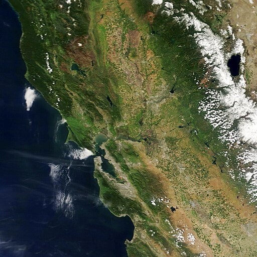
Dike Swarms in California
Scientists are still trying to explain the complexity of this fault geometry, as they present a challenge in evaluating regional seismic hazards. In a study by U.S. Geological Survey scientist Johanna M. Nevitt, experts explored the relationship between active faults and older igneous dikes in southern California.
When a crack cuts through rocks and gets filled with magma, it leads to a cross-cutting feature called a dike. When a collection of dikes intrudes into the continental crust, a dike swarm is formed.
In eastern California, a large group of northwest-trending dikes formed 148 million years ago. Known as the Independence dike swarm, this ancient geologic feature includes an integral part of the Earth's crust and is considered a zone of weakness. In fact, large earthquakes in southeastern California have taken place within the footprint of the Independence dike swarm.
Meanwhile, another geologic structure called the Mt. Tule dike swarm can be found approximately 65 miles east of San Diego near Jacumba, California. It shows a variety of strikes and dips with varying degrees of rock deformation in the form of folds and bends. It also has a general trend of strike evident from satellite images and a general trend of dip confirmed by fieldwork.
READ ALSO : Earthquake Prediction May Finally Be Possible; GPS Data Offers Way of Detecting Underground Tremors
Predicting Future Tremors
Understanding dikes' influence on the crust's mechanical properties plays an important role in understanding the occurrence of large earthquakes.
Using remote sensing data, field observations, and mechanical modeling of the 2019 magnitude-7.1 Ridgecrest earthquake, Nevitt and her colleagues investigated the geological history of southeastern California and its role in controlling the slip distribution. They discovered that slip distribution is mainly controlled by the geometry of the fault and the orientation of stress in the crust.
The fault geometry in the region closely follows the surrounding Independence dike swarm. It was suggested that the dikes and the fractures associated with them served as weakened zones that have currently become a series of faults.
Suppose individual structures such as dikes and fractures within the Independence dike swarm have the potential to reactivate. In that case, the formation of faults along these existing zones of weakness might make sense since they provide the planes ready to slip.
However, the causal relationship between dikes, rotation of faults, and regional seismicity may not be straightforward. Because of this, additional geological investigations might be required.
RELATED ARTICLE : Why the California Earthquakes Were Back-to-Back
Check out more news and information on Earthquake in Science Times.
© 2026 ScienceTimes.com All rights reserved. Do not reproduce without permission. The window to the world of Science Times.


