Before and after satellite photos of the Mississippi River showed the changes in the largest drainage basin in the United States. Apparently, the river is disappearing.
Mississippi River Disappearing
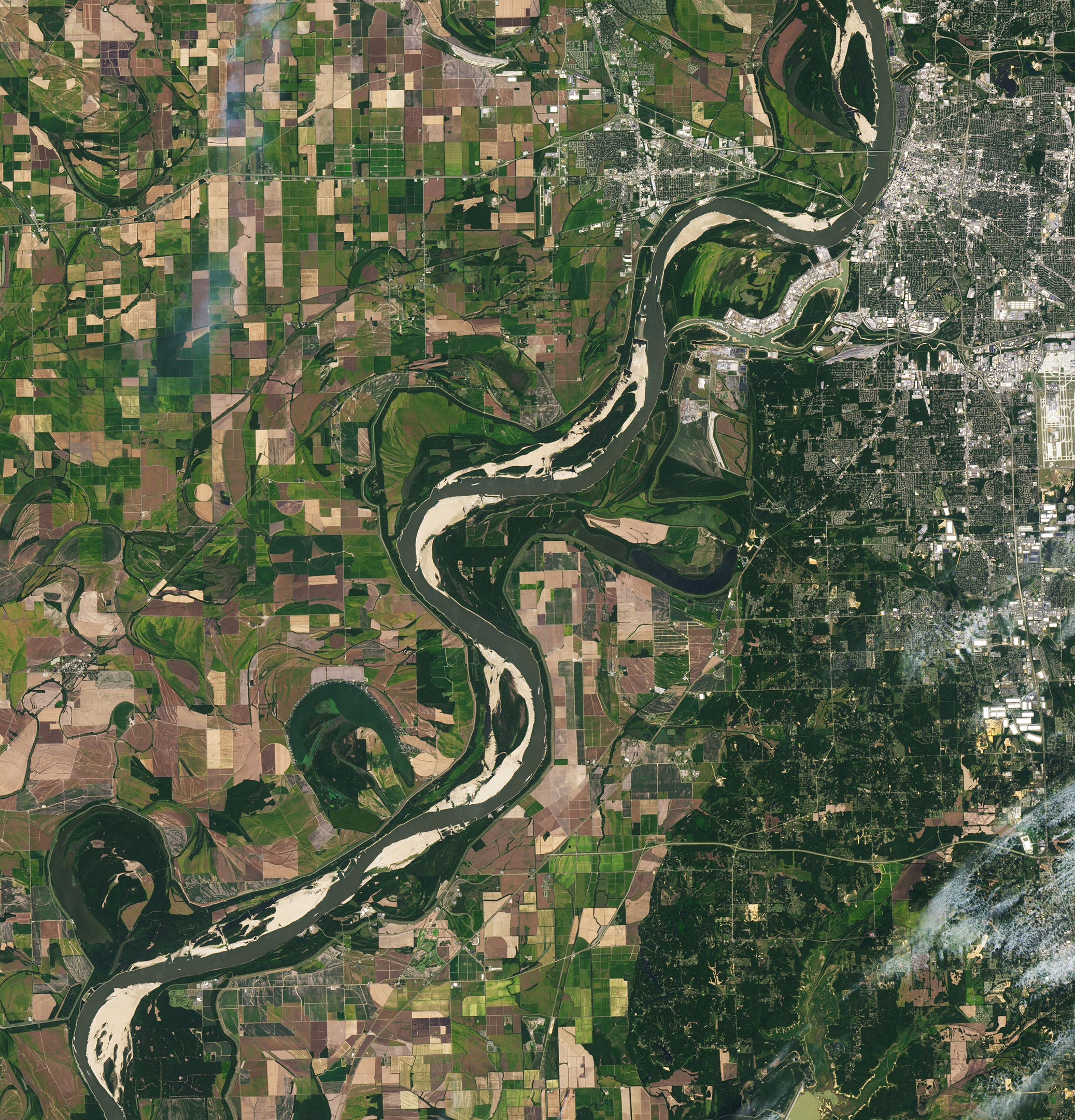
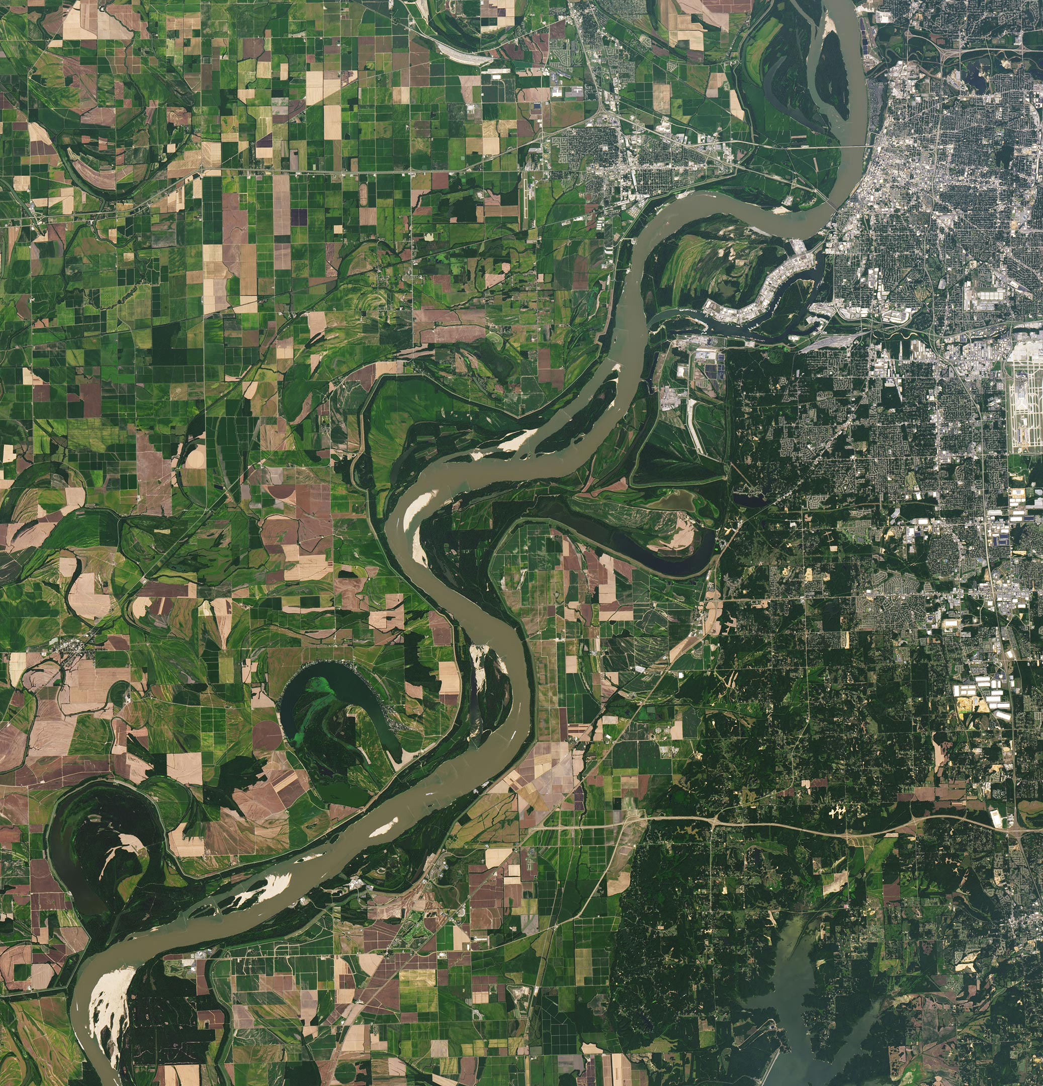
NASA Earth Observatory released photos of the Mississippi River from Sept. 10, 2021, and Sept. 16, 2023. The snaps show the same section of the river in Memphis, Tennessee.
The river is noticeably smaller and has a weaker water flow in the photograph from 2023. It is drastically thinned, revealing some of the river bottom. In contrast to the picture taken in 2021, the river's bottom is much more exposed.
The Mississippi River has been drying up due to the 2023 summer and fall's extreme heat and protracted drought. It dried up by months of extreme heat and drought in the summer and early fall of 2023. Low water levels in September restricted barge deliveries downriver and imperiled drinking water supplies in certain areas in Louisiana.
Due to drought, the river has dropped to nearly record lows at many gauges for the second year. The river level at a gauge near Memphis on Sept. 26, 2023, came close to the record low level, -10.81 feet, measured at the same location on Oct. 21, 2022. Since the National Weather Service began keeping records in 1954, that was the lowest level ever seen.
Water levels, or "gauge heights," are measured about a specified reference point rather than representing a stream's depth. For this reason, some gauge height measurements are negative.
Why Water Levels Dropped So Love in 2023?
Further upstream, since early September 2023, water levels at New Madrid, Missouri, have been close to the minimum operating level at roughly -5 feet. The Mississippi River's water levels typically drop in the fall and winter, but in 2022, the river did not reach that level until mid-October.
The leading cause of the 2023 water level decline was a hot, dry summer. The summer of 2023 saw global temperatures rise by 1.2°C (2.1°F) over average. Louisiana and Mississippi had their hottest Augusts on record in the United States.
The U.S. Drought Monitor map between Sept. 20 and Sept. 26, 2023, shows the progression of the color of the drought from orange to red. The analysis is based on examining soil, water, and climate measures from more than 350 federal, state, and municipal observers around the country.
Lake Mead's water levels have also dropped. The reservoir's water levels stood at 1,065.71 feet as of Oct. 6. In the middle of September, the water level was at 1,066.46 feet.
NASA makes measurements and models available to help in drought monitoring. About 38 percent of the contiguous United States suffered drought during that period. Soils in Mississippi River Valley states were badly dried out over several months due to a lack of precipitation and high temperatures.
As of Sept. 24, 80 percent of Louisiana's soils were dry (or very short on water), according to the Drought Monitor. Over 50 percent of the topsoil in most river valley states was also dry or extremely dry.
RELATED ARTICLE: Tree Farts Account for One-Fifth of the Greenhouse Gases, Will Worsen as Sea Level Rises
Check out more news and information on Climate Change in Science Times.
© 2026 ScienceTimes.com All rights reserved. Do not reproduce without permission. The window to the world of Science Times.


