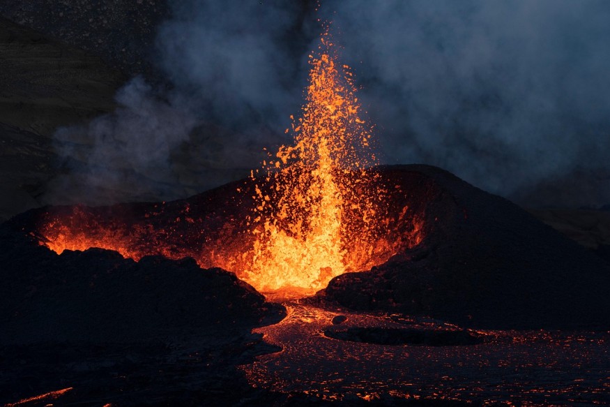
Volcanoes are among nature's most powerful forces, capable of reshaping landscapes and impacting global climates. Despite their unpredictability, modern science shows that there are volcanic warning signs that we can see to somewhat anticipate these events.
Through decades of observation and innovation, geologists have learned to detect subtle and measurable signs that a volcano is becoming active. These volcanic warning signs, from ground tremors to shifts in gas emissions, offer vital clues for eruption prediction and public safety.
What Are the First Signs a Volcano Is Going to Erupt?
The earliest volcanic warning signs often appear weeks, months, or even years before an eruption. Geologists rely on multiple indicators to recognize when magma is moving toward the surface.
One of the most consistent signs is an increase in seismic activity. As magma forces its way through cracks underground, it causes small earthquakes known as volcanic tremors. A rise in both the frequency and intensity of these tremors usually suggests that magma is ascending. For instance, before the 1980 eruption of Mount St. Helens, hundreds of small quakes were recorded beneath the mountain, clear evidence of magma movement.
Ground deformation is another significant signal. When magma accumulates below the surface, it pushes and warps the overlying rock, causing the ground to bulge or tilt. Using high-precision GPS equipment and satellite-based radar (InSAR), scientists can detect even a few centimeters of ground swelling. At Hawaii's Kilauea volcano, satellite data revealed such uplift months before eruptive activity began, helping officials issue timely alerts.
In addition, changes in gas emission rates offer crucial insights. Volcanic gases, especially sulfur dioxide (SO₂) and carbon dioxide (CO₂), increase as magma nears the surface and releases pressure.
A sudden spike in these gases often points to magma rising or fracturing rocks underground. Thermal sensors can also detect rising temperatures in fumaroles, hot springs, and nearby lakes, an indication of renewed volcanic heat beneath.
How Do Scientists Predict a Volcanic Eruption?
Accurate eruption prediction relies on an integrated monitoring approach using seismic, geochemical, and geophysical data. While no single measurement can guarantee a precise forecast, combining different datasets allows scientists to make informed assessments about what a volcano might do next.
Seismographs remain the cornerstone of volcano monitoring. They record vibrations produced by rock fracturing and magma flow. When shallow earthquakes cluster beneath a volcano, it typically marks magma movement upward. Scientists analyze these patterns to estimate the depth, direction, and speed of magma ascent.
Ground deformation studies complement seismic observations. Continuous GPS networks and tiltmeters installed around volcanoes track minute surface shifts. If models show rapid inflation over a short period, geologists infer rising pressure in the magma chamber. When such signals are accompanied by increasing gas output, the likelihood of an eruption grows.
Remote sensing technology adds another layer of intelligence. Satellites can measure changes in surface temperature, gas concentration, and ground elevation across wide areas. These observations feed into computer models that simulate eruption prediction scenarios, allowing scientists to calculate risk levels.
Despite these tools, uncertainty remains. Some volcanoes show clear precursors but never erupt, while others erupt with minimal signs. Prediction is therefore expressed in probabilities or alert levels rather than definitive timelines.
What Role Does Magma Movement Play in Volcano Warnings?
At the heart of all volcanic activity lies magma movement, the motion of molten rock from deep within Earth toward the surface. Tracking this movement is crucial because it drives nearly every measurable precursor of eruption.
As magma rises, it melts surrounding rock and creates a network of conduits. The pressure from this underground motion produces detectable signals: earthquakes, uplift, and temperature shifts. Seismologists detect low-frequency "harmonic tremors," often considered direct evidence of magma pushing through narrow channels.
Advanced monitoring systems such as tiltmeters and InSAR can reveal changes in surface shape caused by this subsurface movement. When magma accumulates in a chamber or shallow reservoir, the overlying land inflates, much like air filling a balloon. If pressure continues to build without release, the rock eventually fractures, creating pathways for an eruption.
The 2018 Kilauea eruption in Hawaii is a well-documented case where magma movement tracking allowed authorities to issue early evacuation warnings. Scientists noted expanding bulges and increased seismicity months before lava began flowing, confirming the close relationship between magma migration and surface activity.
Can Animals or Nature Sense a Volcanic Eruption Before Humans?
There is anecdotal evidence suggesting that animals react to volcanic warning signs before humans can detect them. Reports throughout history describe birds flying away from volcanic areas and pets behaving restlessly days before eruptions. Scientists theorize that animals might sense subtle vibrations, ground deformations, or gas changes that exceed human perception.
However, while such behavior can be intriguing, it is not considered a reliable indicator for eruption prediction. Animal instincts can be influenced by many unrelated environmental factors. In contrast, scientific monitoring offers quantifiable and repeatable measurements that underpin formal volcanic forecasting systems.
How Accurate Are Volcanic Eruption Predictions?
The accuracy of eruption prediction has improved dramatically over the last few decades. In the past, most eruptions occurred without warning. Today, with advanced monitoring and communication networks, many can be anticipated hours or days in advance.
Modern volcano observatories continuously record ground motion, gas emissions, and thermal readings. Machine learning and data analytics enhance interpretation by recognizing patterns across vast amounts of data. For example, algorithms can detect subtle correlations between seismic frequency and gas output that might escape manual analysis.
Still, predicting the exact timing and scale of an eruption remains complex. Each volcano behaves differently based on its composition, pressure, and geological setting. Some, like Italy's Mount Etna, show frequent activity with clear patterns; others, such as Mount Fuji, may remain dormant for centuries with uncertain reactivation phases.
Scientists often frame their forecasts in terms of likelihood, classifying volcanoes as "restless," "likely to erupt," or "currently stable" based on the convergence of warning signs.
How Do Scientists Communicate Volcanic Warnings to the Public?
Scientific observation is only part of effective hazard mitigation. Once volcanic warning signs reach a certain threshold, communication becomes essential. Agencies like the U.S. Geological Survey (USGS) and global counterparts use alert levels and color-coded warnings to convey risk to local authorities and residents.
These alert systems translate technical data into accessible information. For example:
- Normal (Green): No significant unrest.
- Advisory (Yellow): Signs of elevated activity detected.
- Watch (Orange): Eruption possible or ongoing but limited.
- Warning (Red): Hazardous eruption imminent or underway.
Governments and emergency services rely on these updates to coordinate evacuations, close airspace, or issue public advisories. In densely populated regions, such as Indonesia or the Philippines, early alerts have saved thousands of lives. Continuous outreach and education ensure people understand what each alert level means and how to respond appropriately.
Understanding how volcanoes warn us before erupting reveals the intricate link between Earth's inner dynamics and our ability to interpret them. From seismic tremors and magma movement to shifts in gas composition, every volcanic signal contributes to a more complete picture of subsurface activity.
While eruption prediction will never be perfect, technological advances continue to narrow the uncertainty. The combination of ground-based instruments, satellites, and predictive modeling gives humanity its best defense against one of nature's most dramatic displays of power.
As research improves, so does society's capacity to coexist safely with volcanoes, watching and interpreting their warnings before the next great eruption unfolds.
Frequently Asked Questions
1. How far in advance can scientists usually detect volcanic warning signs?
Scientists can sometimes detect volcanic warning signs months to years in advance when a volcano is well-instrumented and shows a gradual increase in activity, such as long-term ground uplift or recurring seismic swarms.
In many hazardous cases, the most actionable forecasts occur only days to weeks before an eruption, when multiple signals, seismicity, deformation, and gas changes, shift rapidly from background levels.
2. Do all active volcanoes around the world have monitoring systems in place?
Not all active volcanoes are closely monitored; instrumentation is often prioritized where large populations or critical infrastructure are at risk, leaving many remote or low-risk volcanoes with minimal or no permanent sensors.
Global networks and satellite remote sensing help fill some gaps, but limited funding and access mean that eruption prediction remains more reliable at well-studied, heavily monitored volcanoes than in remote regions.
3. What is the difference between background activity and unrest at a volcano?
Background activity refers to the normal, low-level state of a volcano, where small earthquakes, gas emissions, and steam release occur at stable, long-term rates with no signs of escalating magma movement.
Unrest describes a shift away from this baseline, such as increased seismicity, swelling of the volcano, or higher gas output, that suggests new magma or fluids are intruding and the chances of an eruption are rising.
4. How do volcano alert levels help communities respond to eruption risks?
Volcano alert levels and color codes translate technical monitoring data into simple categories that officials and the public can act on, such as advising preparedness, restricting access, or triggering evacuations.
As activity escalates through higher alert levels, authorities can progressively implement road closures, aviation warnings, and emergency plans to reduce casualties and damage if an eruption occurs.
© 2026 ScienceTimes.com All rights reserved. Do not reproduce without permission. The window to the world of Science Times.


