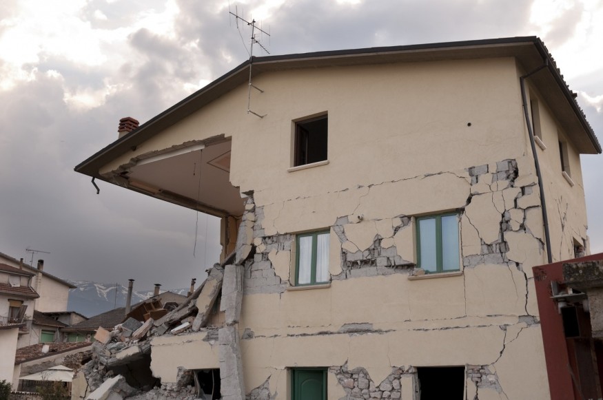
Papua New Guinea was hit by a powerful 7.6 earthquake that resulted in landslides, cracked roads, and collapsed buildings Sunday. Yet, the extent of the damage is still unknown.
An Earthquake Hits Papua New Guinea in 2022
According to the United States Geological Survey, the earthquake occurred close to Kainantu, a town with a population of about 8,500, at a depth of about 90 kilometers (about 56 miles). The US National Tsunami Warning Center added that there was no threat of tsunami waves. Although earlier that day, there were reports of a possible hazardous tsunami wave within 1,000 kilometers (roughly 621 miles) along the coasts of Papua New Guinea and Indonesia.
In 2018, CNN reported an earthquake of a similar size that hit the country's remote highlands. It killed more than 60 people and wounded 500. The earthquake has destroyed houses, causing landslides and damaging a major gas plant.
Papua New Guinea Earthquake 2022 Casualties and Damages
The United Nations Office for the Coordination of Humanitarian Affairs (OCHA) in Asia and the Pacific reported at least four deaths and four injuries, despite the government withholding a death toll.
According to a report sent on Twitter by the OCHA's PNG disaster management team, one person was killed in a landslide in Rai Coast, Madang, while three others were buried in Wau, Morobe.
The airport is still open, although there were reported damages to the local electricity grid, internet cables, and local roadway. For immediate care, some of the injured were airlifted.
Papua New Guinea Earthquake History
A 7.0 magnitude earthquake with a maximum Mercalli intensity of VIII struck Papua New Guinea on July 17, 1998. It is classified as a severe earthquake.
The incident occurred on a reverse fault near Papua New Guinea's north coast region, about 25 kilometers (16 miles) from the coast near Aitape. It killed at least 2,183 to 2,700 people and injured thousands more. It was regarded as one of the deadliest tsunamis of the twentieth century.
Hugh Davies wrote in his book Aitape Story about the 1998 event that families in the coastal villages were gathered for their evening meals when the initial earthquake struck. It was also the start of week-long school vacation, so students had returned from boarding schools to spend time with their families.
However, the villagers heard a loud boom soon after and went to the beach to investigate the strange noise. They noticed that the sea was boiling or bubbling.
In the distance, they could see a large wave forming. Most of the villagers were caught as they fled from the oncoming waves. A few managed to escape by scaling trees or pushing their boats into the lagoon. People in the waves were violently tumbled and smashed in debris-filled water.
Those who were lucky enough to cling to floating debris were swept out to sea, while those who were unlucky were killed by piles of logs and debris. Three tsunami waves hit in rapid succession. It killed and injured nearly everyone, erasing entire villages.
Papua New Guinea Earthquake 2018 Root Cause
Unlike most tsunamis, which are caused by earthquakes, the tsunami that devastated Papua New Guinea was caused by something else. Scientists determined that the tsunami was caused by a submarine landslide generated by the earthquake because it arrived 10 minutes later than predicted by earthquake sources.
The unusual event sparked interest in tsunami hazards in many parts of the world that were previously not thought to be at high risk of earthquake-generated landslide tsunamis. It also highlighted the importance of every country determining the scope of their tsunami probability hazard and developing a tsunami preparedness plan.
Why Do Earthquakes Occur in Papua New Guinea?
Papua New Guinea is prone to earthquakes because it is included in the Pacific Ring of Fire, a particularly seismically active region of the world. In fact, the Ring of Fire is responsible for 75% of the world's earthquakes.
The country lies at the intersection of two major plates, the Pacific Plate and the Australian Plate. When two plates collide, an earthquake occurs. The collision generates an earthquake that can be felt for miles around. This explains why earthquakes are so common in this region.
RELATED ARTICLE : Magnitude 7.2 Earthquake Jolts Haiti; Here's Why This Caribbean Country Is Prone to Disasters
Check out more news and information on Environment in Science Times.
© 2026 ScienceTimes.com All rights reserved. Do not reproduce without permission. The window to the world of Science Times.


