What causes tornadoes is rooted in supercell thunderstorms, where rotating updrafts produce mesocyclones capable of extreme winds. These storms thrive under high instability and strong vertical wind shear, creating conditions for vortex funnels exceeding 200 mph. How tornadoes form relies on Convective Available Potential Energy (CAPE) above 2000 J/kg and 0-6 km shear greater than 40 knots, which together intensify rotating updrafts into tornado-producing supercells. Tornado science classifies intensity via the EF0-5 scale using three-second gusts, with around 1,200 tornadoes touching down annually in the United States, peaking in May and June. Understanding these dynamics is crucial for forecasting, risk reduction, and protecting lives and property.
Advanced radar systems and mobile observations have improved tornado tracking, allowing meteorologists to analyze hook echoes and debris signatures. By combining atmospheric modeling with real-time monitoring, scientists can issue timely warnings, reducing fatalities and economic losses. Studying tornado formation also illuminates broader atmospheric processes, revealing the complex interplay of moisture, instability, and wind shear that drives extreme weather events across Tornado Alley and beyond.
Supercell Dynamics and Mesocyclones
Supercell lifecycle begins when dryline collisions spawn towering 50,000-foot anvil clouds with divergent winds aloft exceeding 100 mph. These collisions create a concentrated zone of rising warm, moist air, which forms the foundation for rotation and updraft intensification.
What causes tornadoes often originates in the rear-flank downdraft (RFD), which undercuts inflow, intensifying rotation via vorticity stretching. Hook echoes on radar can signal imminent touchdown, as mesocyclones tilt horizontally and stretch vertically, amplifying winds up to tenfold. These mesocyclones are the core of tornado formation, persisting for hours while feeding energy from warm, moist inflow. Supercell updrafts also create overshooting tops that puncture the tropopause, enhancing storm longevity and severity. Understanding these dynamics is crucial for predicting tornado intensity and improving warning lead times.
- Dryline collisions trigger supercell development. These boundaries between hot, dry air and moist, unstable air act as a catalyst for rotation and updraft formation.
- Rear-flank downdraft accelerates rotation. Cool descending air from the RFD wraps around the base, stretching the vortex vertically and tightening wind speeds.
- Hook echo radar signatures precede tornado formation. Meteorologists use these distinct radar shapes to identify mesocyclone rotation and potential touchdowns.
- Mesocyclone tilting enhances vertical wind speeds. Horizontal rotation tilts into the vertical, intensifying the tornado funnel and increasing the risk of high-end EF3–EF5 events.
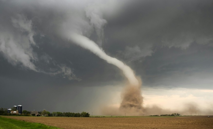
The Vortex and Pipe Effect
How tornadoes form is heavily influenced by the dynamic pipe effect, where surface friction slows winds, concentrating angular momentum upward into a tight, spinning vortex. This process allows the lower-level air to rotate faster as it rises, forming the characteristic narrow funnel that can reach extreme wind speeds.
Tornado science reveals that many storms feature multiple vortices, with sub-vortices orbiting a parent funnel and reaching EF5 strength of over 300 mph, capable of destroying entire neighborhoods. Cold pool collisions and downdraft interactions trigger spin-up events, while latent heat release from rising instability fuels mesocyclone expansion across a 20 km width. This combination of vertical stretching, rotational momentum, and thermodynamic energy explains why tornadoes can rapidly intensify and produce extreme damage within minutes.
- Angular momentum concentrated by surface friction. Friction near the ground slows winds at the surface, causing air above to spin faster, forming a narrow, powerful funnel.
- Sub-vortices increase peak wind intensity. Tornadoes often contain multiple smaller vortices that rotate around the main funnel, concentrating destructive energy at localized points.
- Cold pool interactions promote spin-up. Descending cold air from downdrafts collides with warm inflow, creating tight rotation and rapid tornado formation.
- Latent heat energizes the mesocyclone. Moist air rising releases heat, enhancing the updraft and maintaining the vortex structure longer, enabling EF4–EF5 tornado development.
Environmental Ingredients and Tornado Alley
Tornado science identifies moisture, lift, instability, and shear as key ingredients converging in the Great Plains' Tornado Alley. What causes tornadoes intensifies at night due to the low-level jet (LLJ), which peaks between 2-4 AM, increasing directional shear near the surface. Dissipation occurs as vortex breakdown chokes parent circulation, and suction vortices vanish when inflow collapses.
- Moisture and lift fuel storm initiation.
- Instability and shear promote rotation.
- Nocturnal low-level jets amplify tornado potential.
- Vortex breakdown marks dissipation.
Climate Trends and Technological Advances
Climate trends indicate a 15% increase in EF2+ tornadoes since 1950, altering risk patterns. Tornado science now leverages dual-polarization radar to detect debris signatures with 90% accuracy. Mobile mesonet trucks provide 1 km wind resolution, enhancing snowcasting and improving lead times for warnings by up to 20 minutes. These technologies are critical for reducing fatalities and property damage.
- EF2+ tornadoes up 15% since 1950.
- Dual-polarization radar detects debris.
- Mobile mesonet improves wind measurements.
- Nowcasting enhances warning lead times.
Conclusion
What causes tornadoes via how tornadoes form and tornado science emphasizes monitoring shear and CAPE to save lives through timely warnings. Supercell dissection exposes the violent yet fascinating processes driving extreme weather, while engineering standards mitigate billions in annual damages. The integration of meteorological research with technology provides critical insight into tornado formation, enabling communities to prepare for and respond effectively. Understanding tornado dynamics not only safeguards life and property but also advances broader knowledge of atmospheric behavior, informing climate adaptation strategies and emergency planning for regions at risk.
By combining environmental monitoring, radar innovations, and predictive modeling, scientists continue to unravel tornado formation complexities. With climate trends showing stronger and more frequent EF2+ events, ongoing research is essential to maintain public safety. Preparedness measures, public awareness, and infrastructure resilience remain key to mitigating the impacts of these destructive storms.
Frequently Asked Questions
1. What causes tornadoes' main ingredients?
Tornadoes form when several atmospheric ingredients converge, including wind shear, instability, moisture, and lift. Wind shear creates rotation in the atmosphere, while instability allows warm air to rise rapidly. Moisture fuels cloud formation and latent heat release, intensifying updrafts. Lift, often from fronts or drylines, triggers the storm to develop into a supercell capable of producing tornadoes.
2. How do tornadoes form a supercell lifecycle?
Tornado formation begins with a mesocyclone inside a supercell thunderstorm. The rear-flank downdraft (RFD) interacts with inflow, stretching the rotating air vertically to create a funnel. Sub-vortices often form within the main funnel, increasing destructive potential. As the mesocyclone matures, the tornado may touch down, causing EF-rated damage depending on wind intensity.
3. Tornado science strongest category?
The strongest tornadoes are classified as EF5, with winds exceeding 200 mph. These tornadoes can destroy well-built homes, toss vehicles, and level entire neighborhoods. EF5 tornadoes are rare, representing less than 1% of total US tornadoes annually. Their intensity depends on extreme shear, high CAPE values, and optimal moisture-lift interactions in the storm environment.
4. Tornado Alley shift?
Recent climate trends show tornado activity increasing in the southeastern United States. While the traditional Great Plains "Tornado Alley" still sees frequent storms, more EF2+ events are occurring further east. Warmer Gulf moisture and shifting jet stream patterns contribute to this migration. This trend emphasizes the need for improved monitoring, warning systems, and preparedness in new high-risk regions.
© 2026 ScienceTimes.com All rights reserved. Do not reproduce without permission. The window to the world of Science Times.


