Modern archaeologists unearthed a Bronze-Age stone slab which they believe is Europe's oldest map. Researchers said that the markings on the stone are unfamiliar, having carved contours that now only hint at a landscape from a long time ago.
The stone slab measures 2 meters by 1.5 meters (5 feet by 6.5 feet), which was first discovered in 1900 and was found again over 100 years later in 2014 in a castle in France.
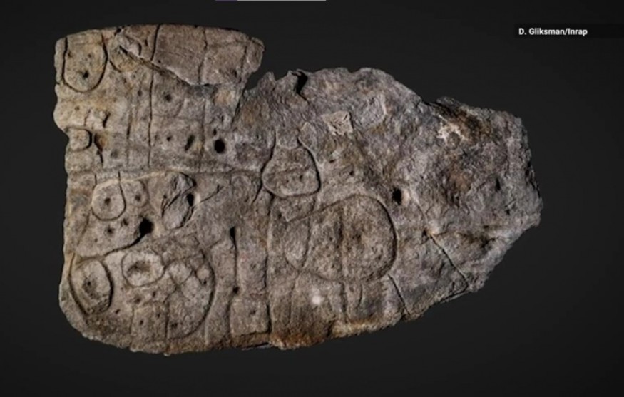
Archaeologists said that the patterns engraved in the 4,000-year-old stone slab are a map of an area in western Brittany.
Saint-Bélec Slab Could Be Oldest Map of Europe
The piece of stone slab recently rediscovered is called the Saint-Bélec Slab, believed to date between 1900 BC and 1650 BC during the Bronze Age, according to The Guardian.
French prehistorian Paul du Chatellier found the stone slab when he was excavating the engraved slab from the ancient burial mound in the town of Leuhan in Brittany, France.
At that time, du Chatellier wasn't sure what the engravings on the stone slab meant, so he invited some scholars who said that the markings could represent a human or perhaps a beast. But they suggested that maybe the meaning behind these markings can only be interpreted by further research.
He stored the slab under his home, the Château de Kernuz before his children sold it to the French Museum of National Archaeology. The museum stored the stone slab in isolation for a century in the niche of a castle moat until it was forgotten and rediscovered in 2014 by modern archaeologists.
Study lead author Clément Nicolas from Bournemouth University in the UK and his international team was the first to conduct modern analysis on the slab using 3D surveying techniques that looked into the stone's morphology and chronology. He told the BBC that this rediscovered stone slab might be Europe's oldest map of known territory.
"There are several such maps carved in stone all over the world. Generally, they are just interpretations. But this is the first time a map has depicted an area on a specific scale," Nicolas said.
ALSO READ : Australia's Oldest Rock Painting of Kangaroo Found To Be 17,000-Year-Old Thru Radiocarbon Dating
Saint-Bélec Slab: A Way to Ownership of A Territory
The stone slab analysis revealed that the engravings showed repeated motifs joined by lines that suggest that it was a map of an area of Finistère.
Researchers said that it was a 3D representation of the River Odet valley wherein several lines represent the river network. Geo-location confirms that the slab represented 80% accuracy of the area that is 18 miles long.
Nicolas said that although there have been many maps found in the past, this stone slab is the first to depict an area of a specific scale and that it might have been used to mark a particular area, Science Alert reported.
He added that it was probably a way to affirm a prince's or king's ownership of the territory at that time. Interestingly, the slab highlights the cartographical knowledge of past societies that are mostly underestimated today.
RELATED ARTICLE: Dead Sea Scrolls Found Recently: Fragments of Biblical Texts That Have Not Been Seen In Decades
Check out more news and information on Archeology on Science Times.
© 2026 ScienceTimes.com All rights reserved. Do not reproduce without permission. The window to the world of Science Times.


