Landsat 9, a cooperative mission of NASA and the United States Geological Survey (USGS), will now assist specialists in evaluating crop health and irrigation throughout the planet. The investigation will also aid in managing critical natural resources and understanding climate change's effects.
It comes as the USGS and the US space agency (via Science Times) revealed the newest photographs of Earth from orbit, which give unique views of how the planet's surface is changing.
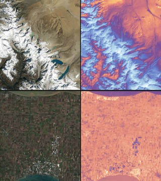
USGS said Landsat satellites offer high-quality, multi-spectral photography of the Earth's surface. These remotely sensed, moderate-resolution photographs are more than simply photos; they contain many layers of data acquired at various places along the visible and invisible light spectrum.
Landsat-9 To Observe How Earth Changed Over Time
Karen St. Germain, Earth Science Division director at NASA Headquarters in Washington, said in a SciNewsDaily report that the data and photographs from Landsat 9 are extending the potential to observe how Earth has evolved over decades.
NASA said city planners, farmers, scientists, and other stakeholders may use the newly obtained data to make better-informed decisions on crop health, irrigation use, water quality, wildfire severity, deforestation, glacial retreat, urban growth, and other topics.
ALSO READ : NASA Landsat 9: Secondary Payloads Begin Commissioning To Observe How Climate Change Affects Earth
Images from the Navajo Nation in the western United States, for example, will help with drought monitoring and irrigation water management. With just 85 rain gauges covering more than 27,000 square miles, data has been grossly insufficient; satellite images and climate models fill in the gaps, allowing the Navajo Nation to track the severity of the drought, according to NASA/USGS. Landsat 9 photographs swirls of green algae in the Great Lakes to aid scientists and resource managers detect algal blooms early.
About Landsat 9
According to Eyewitness News Channel, Landsat 9 flies at 438 miles above Earth. Every day, it takes about 700 images of the Earth while cruising at an incredible 16,760 miles per hour! On September 27, 2021, NASA launched the probe from Space Launch Complex 3 at Vandenberg Space Force Base in California.
Its launch marks the continuation of Landsat's long history of remotely monitoring Earth's land and coastal areas. The satellite will provide data on tropical deforestation, water quality monitoring, and agricultural status reporting.
That's not all; anyone interested in viewing more images taken by this satellite and how they look may click here to learn more about the program! Once the satellite is operational for the general public, you may zoom in on the area you want to observe from the perspective of Landsat 9.
Read also: NASA Landsat 9: Secondary Payloads Begin Commissioning To Observe How Climate Change Affects Earth
Check out more news and information on Space in Science Times.
© 2026 ScienceTimes.com All rights reserved. Do not reproduce without permission. The window to the world of Science Times.


