NASA and the United States Geological Survey (USGS) shared the first Landsat 9 photos of Earth. The illustrations depict how the mission will assist people in managing key natural resources and comprehending climate change's effects.
The Landsat 9 satellite, launched two months ago (per Science Times), is the most recent in the Landsat series. This collaborative NASA-USGS project is an essential part of the worldwide plan to monitor Earth's health and status.
NASA, USGS Shares First Images from Landsat-9
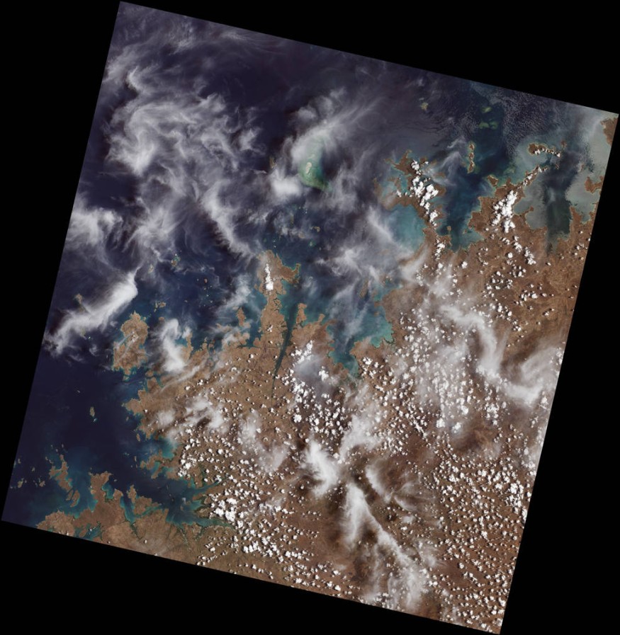
NASA and the USGS have published the first photographs of the Landsat-9 satellite, which everyone can find on NASA's website. The photos depict what the spacecraft saw in its early days. The satellite displays various portions of the globe, concentrating its cameras and other instruments on particular spots designated by NASA and the USGS to be monitored.
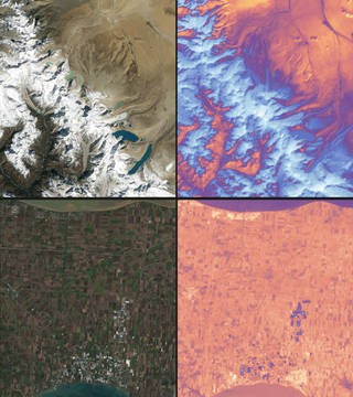
These first light images from the space agency's gallery show Detroit, Michigan, with Lake St. Clair nearby, the connection of cities and beaches along an evolving Florida coastline, and Navajo Country in Arizona. The new pictures also revealed the altering landscapes of High Mountain Asia's Himalayas and Northern Australia's coastline islands and shorelines. All of which will contribute to the wealth of data that will help scientists and other experts monitor crop health and manage irrigation water.
The Landsat-9 gives a fresh viewpoint on seeing more of the Earth than aerial images, providing a different point-of-view on a greater scale. The photographs are viewable online, and visitors may learn more about the present status of the Earth's geological structure.
NASA and USGS researchers and scientists examine these photos and are now available for viewing.
ALSO READ : Europe's New Satellite Constellation to Monitor Earth's Greenhouse Gas Emissions From Space Soon
About Landsat 9
Eyewitness News Channel said that the newest NASA satellite, Landsat 9, orbits 438 miles above Earth. It captures almost 700 photographs of the Earth every day, all while moving at an amazing 16,760 miles per hour! It took out from Space Launch Complex 3 at Vandenberg Space Force Base in California last month, on September 27, 2021.
Its deployment signifies the continuance of Landsat's heritage of remotely monitoring Earth's land and coastal regions. The satellite will give information on tropical deforestation, water quality monitoring, and agricultural status reporting, among other topics.
That's not all; anyone interested in seeing additional photographs taken by this satellite and how they appear may go here to explore more about the program! Once the satellite starts working for the public, you may zoom in on the region you'd want to see from Landsat 9's perspective.
RELATED ARTICLE : NASA Landsat 9: Secondary Payloads Begin Commissioning To Observe How Climate Change Affects Earth
Check out more news and information on Space in Science Times.
© 2026 ScienceTimes.com All rights reserved. Do not reproduce without permission. The window to the world of Science Times.


