Clouds are one of the simplest and most reliable tools nature provides for understanding the atmosphere. Their shapes, heights, and textures can signal everything from calm skies to developing storms. That's why learning the main cloud types is a foundational part of meteorology basics, used by both amateur observers and professional forecasters.
Knowing how to read clouds offers practical advantages. It helps you anticipate changes before they appear on weather apps, understand when storms may develop, and recognize signs of approaching high- or low-pressure systems. In short, cloud observation gives anyone a clearer view of weather prediction, simply by looking up.
Common Cloud Types and Their Weather Implications
The atmosphere produces a wide range of cloud formations, but seven major cloud types are especially important for predicting upcoming weather. Each type forms under specific conditions and carries unique signals.
1. Cirrus Clouds
High, thin, and wispy, cirrus clouds sit at elevations above 20,000 feet. Composed of ice crystals, they form in cold, dry air. Cirrus clouds often indicate fair weather for the moment, but they can also signal a change in the next 24 to 48 hours, especially if they thicken and lower, which may indicate an approaching warm front or storm system.
2. Cirrostratus Clouds
These thin, sheet-like clouds cover the sky like a veil and frequently produce halos around the sun or moon. Cirrostratus clouds are reliable indicators of moisture moving into the upper atmosphere. When these clouds appear, precipitation—often in the form of rain or snow—may follow within a day.
3. Cirrocumulus Clouds
Cirrocumulus clouds form high in the atmosphere and resemble small, rippled patches. They signal instability aloft, especially when they appear in warm, humid weather. In tropical regions, cirrocumulus clouds can sometimes signal the early stages of developing storms.
4. Altostratus Clouds
Sitting in the middle layer of the atmosphere, altostratus clouds appear as uniform grayish sheets that can block the sun. These clouds usually precede widespread, steady precipitation associated with large-scale weather systems such as warm fronts.
5. Altocumulus Clouds
Altocumulus clouds appear as larger, puffy patches and often indicate moisture in the mid-levels. When these clouds appear in the morning on a warm, humid day, they may signal the potential for thunderstorms later.
6. Stratus Clouds
Low, gray, and uniform, stratus clouds resemble fog that has lifted off the ground. They typically bring overcast conditions and light precipitation, such as drizzle or mist. While not associated with severe storms, they often mark the presence of stable, moist air.
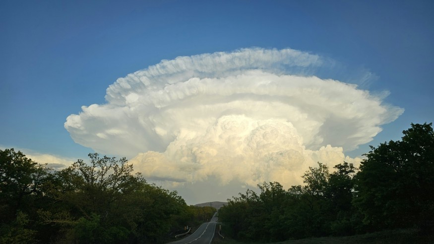
7. Cumulonimbus Clouds
Towering, anvil-shaped cumulonimbus clouds are the giants of the atmosphere and the primary producers of thunderstorms. These clouds form when warm, moist air rises rapidly and condenses. They are associated with heavy rain, lightning, hail, strong winds, and even tornadoes. When these clouds begin growing vertically, it's a strong indication of increasing atmospheric instability and severe weather potential.
How Meteorologists Use Clouds for Weather Prediction
Professionals rely heavily on weather prediction techniques that include cloud observation. By analyzing cloud type, height, density, and evolution, meteorologists can evaluate atmospheric stability and anticipate upcoming conditions.
Cloud Classification Techniques
Meteorologists categorize clouds based on three factors:
- Altitude (high, mid, or low)
- Appearance (wispy, layered, or puffy)
- Vertical development
These characteristics help forecasters determine what processes are occurring in the atmosphere, such as rising warm air or descending cool air.
Forecasting Weather from Cloud Patterns
Cloud changes offer critical clues:
- Increasing cloud height often suggests clearing skies.
- Thickening and lowering clouds may signal a warm front and long-duration rainfall.
- Rapid vertical growth indicates strong convection and a likelihood of thunderstorms.
By observing not just the cloud type but also its movement, meteorologists can predict the timing and intensity of upcoming weather events.
Assessing Atmospheric Conditions
Clouds also help determine:
- Moisture levels in the atmosphere
- Temperature gradients
- Approaching pressure systems
Together, these factors allow forecasters to identify whether precipitation, storm development, or fair weather is likely.
Read more: Why Lightning Strikes: The Science of Lightning Formation and Static Electricity in Thunderstorms
Meteorology Basics: Clouds as Indicators of Atmospheric Conditions
In meteorology basics, clouds are viewed as visible markers of atmospheric processes. They form when moisture condenses around microscopic particles, often in response to temperature and pressure changes.
Atmospheric Pressure and Cloud Formation
- Low pressure encourages rising air, cooling, and condensation—leading to cloud formation and precipitation.
- High pressure pushes air downward, warming it and reducing cloud formation—resulting in clear skies.
Watching the evolution of clouds helps monitor shifts between these systems.
Humidity and Condensation
Higher humidity increases the likelihood of denser clouds and eventually rainfall. When clouds appear to thicken or darken, it usually signals growing moisture in the atmosphere.
Weather Front Indicators
Cloud behavior often reflects the movement of weather fronts:
- Warm fronts bring layered clouds like cirrostratus and altostratus, signaling long-lasting rain.
- Cold fronts tend to trigger cumulonimbus clouds, producing short but intense storms.
Practical Cloud-Reading Tips for Everyday Weather Watchers
- Look at the shape and height of clouds to guess the incoming weather.
- Check whether clouds are thickening, thinning, rising, or lowering.
- Pay attention to the color—darker clouds mean more moisture.
These simple observations make cloud-watching a valuable skill for everyday weather awareness.
Conclusion
Identifying the seven major cloud types gives you a powerful tool for understanding the atmosphere and improving your weather prediction skills. From cirrus clouds that hint at changing conditions to towering cumulonimbus clouds that warn of severe storms, each formation tells part of the story of what's happening in the sky. By applying basic meteorology and regularly observing cloud behavior, anyone can gain insight into atmospheric changes and stay prepared for incoming weather.
Frequently Asked Questions
1. What are the main types of clouds to look for in weather prediction?
Cirrus, cirrostratus, cirrocumulus, altostratus, altocumulus, stratus, and cumulonimbus are the most essential for understanding weather changes.
2. How do clouds indicate different weather conditions?
Each cloud type forms under specific atmospheric conditions, revealing whether the weather will be stable, rainy, stormy, or clear soon.
3. Can cloud observation be a reliable tool for forecasting?
Yes. While not as precise as professional instruments, cloud observation is a fundamental method in meteorology and remains useful for short-term predictions.
4. How do high and low clouds differ in weather signaling?
High clouds usually signal gradual weather changes, while low clouds often indicate precipitation or unstable conditions.
© 2026 ScienceTimes.com All rights reserved. Do not reproduce without permission. The window to the world of Science Times.


